Unaka

15 MAY 15
Unaka/Erwin Trip: Day 1
Iron Mountain Gap-Unaka Mountain
Miles today: 6.4

“Each fresh peak ascended teaches something.”Sir Martin Convay


20150515_103540

For once I arrived at my shuttle pick-up location on time. For the past couple of days, I’d been putting away a lot of water so I wouldn’t be dehydrated getting on the trail. It definitely worked, because I stopped 3 times between Charlotte & Erwin. I arrived at Uncle Johnny’s Nolichucky Hostel & Outfitters right at 0950 for my 1000 shuttle. Uncle Johnny’s was going to shuttle me, but they couldn’t get me out until noon, and I wanted to be out by 10, so I went with Tom “10K” Bradford.

10K was the shuttler whose info was on the business card I took down at Devil Fork Gap last September. I  had texted them that I’d taken their last card, and wouldn’t you know, he & his wife put 2+2 together and remembered me!. 10K (who has hiked the PCT) was a pretty cool guy. When I told him my plans to stop at Unaka & camp out instead of pushing on to Beauty Spot, he said that was the best thing to do. Beauty Spot has a lot of open campsites (it’s a bald summit), but there’s a Forest Service road & parking area right off of it, and with this being a Friday, no way did I want to contend with drunken locals. 10K suggested that I top off with enough water for dinner & breakfast at Cherry Gap shelter, since there wouldn’t be any springs until I come down Unaka to Deep Gap the next morning.

We arrived at Iron Mountain Gap (mi 362.1, elev 3,723 feet) at 1025. I got out, donned my pack, took a look at the white blaze across the road where I’d started my hike back in June last year, and set off southbound towards Erwin. The trail wasn’t bad at all; pretty well graded save a few uneven spots. I felt refreshed and eager to be hiking out here again, and with a base pack weight that was down to about 17 1/2 pounds, felt light on my feet.

 20150515_112200

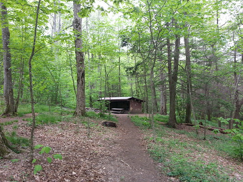
Shortly I arrived at Cherry Gap Shelter (mi 359, elev 4,012 feet). As I was taking a picture of it, I was startled by a man’s voice coming from inside that called out and said “Hey there”. I walked up closer and saw a middle-aged man sitting on the right side of the shelter in a sleeping bag, with a dog tied out along the rafter. “Hi there”. Immediately I wondered if he was a homeless guy- because he kinda looked the part- slightly disheveled, slightly slurred speech, with a crap ton of gear laying about.

Fun Fact: Cherry Gap Shelter was built in 1962 by the US Forest Service.

My plan was to sit here for lunch before heading up Unaka, but now I wasn’t so sure. This guy seemed a little “off”. He introduced himself as “Country Gold”, and his 1-year-old Plothound “Sunshine”, and said he was hiking from Erwin to somewhere in PA. When I asked him how long he was going to take, he said “Oh, I’ll get there when I get there”. I made some small talk, trying to be polite while I munched on a few snack bars and an Os-Cal stick (which, by the way, was pretty damn good). He noticed my MRE’s and said he was familiar with them, then went on to tell me Lillington about 15-20 years ago once he found out I was in the Army. He asked if I was hiking alone (stranger danger!) so I said “yeah, I have a few friends that probably stopped for an early lunch”. Why does everyone think it’s cool to ask a woman if she’s hiking alone? Stop it! Anyway, I noticed the reason for his slightly “off” sounding speech was due to the hearing aid he was wearing.

20150515_115618

I went down to the piped spring behind the shelter to camel up and was pleased to see it was a gusher! The water was so cold that it gave me brain freeze a few times when I was chugging it down. Talk about refreshing! Since I wanted to get on my way, I headed back up to the shelter to see that Country Gold had come out of his bag and was sitting at the picnic table, and tied Sunshine out to a tree. He talked about how he stayed at Curley Maple Gap Shelter for a few days, was going to stay here for a day or two,and keep heading north.

No way in hell could I zero at a shelter- that would drive me batshit insane, just sitting there, looking at the walls, watching the vermin scurry around the shelter, and worrying about one of them strolling across my face…Don’t get me wrong, I enjoy being out in the woods, sitting still, enjoying Ma Nature. I can do it for hours on end when I go hunting but I couldn’t just do NOTHING but that all day. I’d have to keep walking unless I was really sick or hurt, in which case I’d call for a ride back to town.

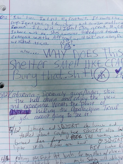
At any rate, we talked about trail towns, hostels, and how Curtis Owen from Standing Bear Farm (the first hostel you reach NOBO exiting the Smokies, or the last sign of civilization for 70 miles heading SOBO into the Smokies). When I mentioned Curtis had died from pancreatic cancer, Country Gold went on to tell me that when his mother had died of pancreatic cancer in 2009, he attempted suicide shortly thereafter, and then put everything he had in a backpack and thru hiked the AT in 2010. At any rate, after I perused the shelter register (someone said it smelled like poop!) I said goodbye and beat feet out of there.

20150515_120101

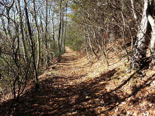
The hill leading away from the shelter was pretty steep, of course. Nothing gets your blood pumping more than stopping for food & water, and then being greeted by the trail’s omnipresent characteristic near vertical climb. As I wound my way thru the forest of blooming wildflowers, a dark ridge became visible through the treeline off to my right. I’d had a feeling that was my target; Unaka Mountain; looming ominously in the not-so far landscape. The Backcountry Navigator app on my phone confirmed it; once again I had a summit in sight, but this time I was ready. Pointing my pole at it in an authoritative manner and muttering I’m coming for YOU, Unaka, I set off.

20150515_131804
Bring it.

Unaka didn’t let me down; the elevation gain was hearty, but not a lung-burner. Remembering my bout with Big Bald last year, I promised myself the first available rock or downed tree I saw that I could use as a seat for a break, I was going to stop for a snack break. Of course, within 45 seconds of that thought, I came upon a perfect rock for that purpose. The trail provides. Halfway up to the summit, the terrain became a lot less steep, and the telltale spruces and firs were beginning to emerge.

20150515_142459
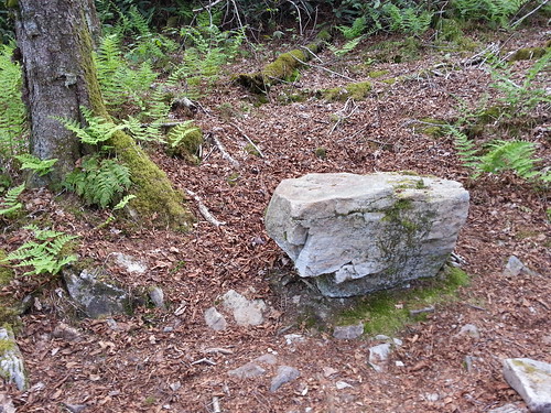
“Upon this rock, I will take a break”

Several hikers have done blogs/videos about Unaka, so I knew exactly when I was entering the dense forest at the summit. You’re walking along in a moderately open area, and as you approach you it looks dark as hell like there’s no light shining in there at all. I showed a friend the picture and he said no way in hell would he have walked in there. Instead of feeling any trepidation, my pace quickened. I was excited to finally be here.

20150515_150036
The doorway to awesome.

The top of Unaka (mile 355.7, elev 5,180 feet) was nothing short of enchanting. Yeah, that’s a corny description but it’s spot on. Bright green moss crept up the tree trunks, in stark contrast to the dark brown bark, and the forest floor was covered in pine needles and moss, making it very soft and spongy. I dropped my pack by one of the fire rings and just walked around, taking it all in. 10-15 years ago I would have never thought I’d be wandering around in a scary-looking forest by myself but this was absolutely cool.

 Way cool indeed.

Fun Fact: The name “Unaka” (pronounced oo-NAY-kuh) is thought to come from the Cherokee Indian word unega meaning “white” or “fog draped”. The town of Unicoi and the county of Unicoi Tennessee are derived from the same name although pronounced differently.

I set up camp, sat down for dinner, which was an abysmal disappointment. I’d bought a Mary Jane’s Farm dehydrated Shepherd’s Pie meal, and was curious as to how it would taste. Take some dry dog food, let it sit in water for a few hours until it’s mushy, toss in some stale mashed potatoes, add a teaspoon of pepper, and voila! you have exactly what this abomination tasted like. YUCK! Believe me, I tried hard to cram it down, but uh-uh, it wasn’t going to happen. The other bad thing was I couldn’t just dump it out (Leave No Trace!) so I had to roll it up as tight as possible, put a piece of 100 mile an hour tape on it (Army slang for heavy-duty olive drab duck tape), and pack it out until I got to Erwin, so I ended up eating tomorrow’s lunch for dinner, putting me a meal down, Luckily I always pack an extra couple snacks stashed away in case something like this happens. Only low point of the day.

20150515_151309

Surprise! I managed to get a somewhat robust fire going (finally! hooray!), and I could smell some other campers had one going. While I was walking around after the horrendous dinner attempt, there was a loud SNAP that came from some unseen part of the forest. Oh shit, just great, I finally get to see this magical place only to be decapitated by Sasquatch. It was someone collecting wood for their campfire, stupid imagination of mine. The rest of the night was spent reading, stretching my legs that cramped up for no apparent reason and moving my tent around to keep the campfire embers from setting it ablaze (I just pulled the stakes and drug it around like a bag lady dragging her shopping cart down the street.

I’m camping on Unaka Mountain. Good times.

Unaka Campsite

20150515_113756

Standing Bear Farm

9 NOV 14
Davenport Gap/Snowbird Trip: Day 3
Snowbird Mountain- Interstate 40 Underpass
Miles today: 4.8

“Discoveries are often made by not following instructions, by going off the main road, by trying the untried.”

– Frank Tyger


HP Snowbird Mountain

Didn’t sleep too bad last night; I guess the cloud cover was just enough to keep the chill away a little. Awoke around 8 and dawdled breaking camp down, no rush since Kelly wasn’t due to meet me at  Exit 451 off of I-40 until around 2. Went back up to the FAA radio tower and took in the sights, snapping a few more pictures, then headed back down Snowbird. When I say headed back down, I mean meandered. Was in absolutley no rush, as there was no need to risk a last-minute spill down the mountainside.

Navigated some of the stupid blowdowns again, but at least I had figured out how to best negotiate them from yesterday. I thought it would be a good idea to mark the bad areas on my GPS and let the folks at the Carolina Mountain Club know about them.

20141109_102329
Heading down from Spanish Oak Gap

I stopped by Painter Branch again to get some water, and as I was getting myself saddled back up I heard a loud rustling noise, like a large mammal was coming down the trail. I stiffened up abruptly, and then breathed a sigh of relief when the cause of the noise was in fact not a black bear, but a group of 4 southbounders loping downhill. They stopped for a quick break and we made our introductions. They were two men, Human Torch and another guy whose name I forgot, and two women, Faith and… damnit I need to start writing these down! Sorry.

20141109_112723
Southbounders!

Anyway, I offered them the rest of my jerky since my hike was done and they were heading into the ever-loving Smokies. We talked about stopping by Standing Bear. I definitely wanted to check that place out. One of them took a smoke break ,while the rest of us headed off. Well, THEY headed off, I just kind of followed. No way in hell was I going to keep up with them, even downhill, even if I threw my pack off and started running. Of course, it wasn’t long before the smoke break guy whizzed past me as well. Such as it is, being a weekend section hiker.

At a clearing under some powerlines, I saw a text from Kelly. I called her and she said that she’d forgotten we were in Central time, not Eastern time, so she was running an hour behind. Also, that she was late getting the kids up & out to breakfast so she was actually TWO hours behind schedule. “No problem” I answered, “I’ll just hang out at the hostel a little while longer”.

Standing Bear Farm Hostel
The Standing Bear Farm cabin, with a standing bear of course!

Once I came down the hill, instead of crossing the gravel road and heading back up the trail, I hooked a right and started up towards Standing Bear. It wasn’t more than .2 miles up the road, but was steep enough to remind my hamstrings what they’d done yesterday. The hostel is actually a group of cabins and out-buildings, with the main house back a little further.

There’s a cabin, a bunkhouse, a laundry area, kitchen building, and a bunch of other cool little things. Definitely not your run of the mill farmstead. I dropped my pack outside the bunkhouse and sat down for a spell. That’s when this guy with long flowing blond hair came up. He had a cigarette in one hand and a plastic tumbler in the other. “Hey how’s it going?” he offered.

20141109_142816
Outside the bunkhouse

“You must be Rocket” I said, smiling. “Yep, that’s me, how’d you guess?” “Oh man, you’re famous. Internet famous”, I replied. We had a laugh. He took me around on a grand tour of the grounds. They have a treehouse there. A literal treehouse you can sleep in. How cool is that? He took me behind the main house where the owners (Curtis & Maria) live, and showed me another one-room outbuilding that Curtis was turning into a single room with a nice view of a pasture. The whole place was bucolic, if not a bit kitschy.

Rocket and I talked about everything under the sun; his service in the US Marines, my current service in the US Army, beer, hiking, mountains, how crazy it gets in the springtime. He said at one point earlier this year he had 40 people TENTING along the grounds- the cabin, bunkhouse, & treehouse were all jam packed. I don’t think I’d want to be around all that craziness, especially having to share an outhouse…

20141109_160403
Ol’ “Rocket” man and me

Maria came into the bunkhouse with a load of fresh blankets and I told her what a cool place this was. I saw Curtis going between the house and the little “store” but didn’t get a chance to meet him- Rocket said he’d be holed up in the house soon watching a football game. I sat around shooting the breeze with Rocket, a guy who lives up the road who came down to visit, & the 4 SOBOs for a couple hours. There was another hiker who was crashed out in the treehouse, but he eventually came down to get some food.

Once the sun ducked down behind the mountain, the temps took a nosedive, enough for me to throw my Revelcloud jacket on, and zipped all the way up. I kicked my feet up for a little while longer, long enough to make note that Rocket loves him some Jim Beam, and donated the rest of my non-perishable food to the other hikers, who were going to try to make it past Davenport Gap Shelter to Cosby Knob. Of course, the suggestion was made that they rest their weary legs for the night. Shotrly thereafter, I got the text from Kelly saying she was passing by Newport, TN, which would be around 30 minutes out, so I bid farewell to Rocket (man) and started down the gravel road to the exit. (No need to head BACK up on the AT- I’d already done that section coming up and the blowdowns were irritating).

20141107_123535-1
Down at I-40

As soon as I got rounded the bend, I saw a white car pull up. It was Kelly, and talk about perfect timing! That’s when I realized the deal we made- I had to drive the other 5 hours back home. I was tired, but had an enjoyable hike.

******************SIDE NOTE***************
A few weeks ago, I’d seen on Whiteblaze and Facebook that the owner of Standing Bear Farm, Curtis Owen, had passed away on 4 MAR 2015 from pancreatic cancer. Only 4 months had passed since I saw him. Goes to show you that life is both precious and short. RIP Curtis.

On Top Of Old Snowbird

8 NOV 14
Davenport Gap/Snowbird Trip: Day 2
Davenport Gap Shelter- Snowbird Mountain
Miles today: 8

“In the mountains there are only two grades: You can either do it, or you can’t.” – Rusty Baille


BRRRRR! Last night was cold. I woke up several times shivering. The fire we made had died out around 10. My brand new Primaloft-filled jacket was balled up under my head as a makeshift pillow, but can you believe I didn’t want to have to unzip my sleeping bag just to put it on? I’d just tense up all the muscles in my body a few times, and fall back asleep, grateful that I didn’t have to go pee. That’s how cold I was.

Anyway, up and at ’em. I made my coffee and paid the obligatory visit to the nasty “toilet area” up on a hill to the west of the shelter, bid farewell to my shelter-mate Night Owl and set off NOBO, retracing my steps. Destination, Snowbird Mountain (or further, who knows?) Once reaching the stupid tangle-o-rama from that almost ripped off my ankle yesterday, I decided to bushwhack 30 feet around the disaster area instead of trying to navigate through it again. Coming down the wooden steps back down toward the bridge, the box of trail magic was still there.

Keeping true to my promise, I perused over its contents and decided for a chocolate chip cookie, signed the register in appreciation, and set off on my merry way. That cookie was good, although my body wasn’t accustomed to having sugar (I’d been on the ketogenic diet for over a month now) and 10 minutes after finishing it, a wave of pure sugar high washed over me, soon followed by a headache. Well, that’s human physiology for you. I’d carry that headache for the next few hours.

DSC01986

Once back under Interstate 40 where my trip started, the trail goes up a long wooden staircase, then meanders around the side of a hill before it drops down to cross Green Corner Road. Now, I could have saved myself a lot of effort and cursing had I just taken the road up from the Interstate exit, but being the purist I am, I didn’t want to skip any white blazes.Trees were down everywhere. Man, it was like going through an obstacle course. To make matters worse, many of them were right where the trail cut across a steep slope, so maneuvering around them meant climbing up-slope, not an easy feat with 30 pounds on your back.

You could tell that Standing Bear Hostel was close by; there was quite the bit of racket down by the road with chainsaws buzzing. Just up from the road was a rock painted with the hostel’s logo in bright orange, and a sign on the back of an AT marker said “Go back to Standing Bear”. Was that an order? Did someone not want me out here? Stop being ridiculous and keep it moving.

More trees down. More climbing over, under, and around them. Some were large trees whose trunks crashed downhill over the trail, blocking the way. Those were easy to navigate. Just throw a leg over, put your butt down, and slide down bringing your other leg over. Some I had to crawl underneath on my hands and knees. Two of them required me to take my pack off, hook my foot through a shoulder strap, and drag it under behind me. The hard part was when the top of the tree (or trees) came down over the trail. Branches and limbs and leaves blocking your view of the ground made it especially hard to navigate. One rather large section of rhododendron was down as well. I remember crawling on all fours through about 20 feet of that. Fun times!

DSC01988
The trail is in here somewhere…

I stopped at a creek called Painter Branch (mi 242.9, elev 2,893′) for a late lunch around 1330. It was a pretty cool looking area where you actually crossed over the creek to get to the campsite, tucked in a draw between two hills.

Fun Fact: “Painter” is actually an Appalachian pronunciation of the word “panther” (otherwise known as a mountain lion). This once widespread predator was hunted to near extinction, but is making a comeback, although not scientifically certified to be in habitat along the Appalachian Trail.

Although the sun was out and I’d built up quite a bit of body heat from the obstacle course, it was still chilly enough to throw my jacket back on. I had gone to the REI in Cary, NC right before the trip for the sole purpose of getting a synthetic fill jacket. My heart was set on a North Face Thermoball. Unfortunately, the North Face jacket was a little too snug around my derriere (go figure) and the sleeves were too short when I raised my arms overhead. The Patagonia Nano Puff fit a little better, but my size (XL) only came in a bright red (I wanted black). The salesperson mentioned the REI Revelcloud, which I knew was going to be heavier, but the fit was almost perfect and it seemed to be a little more windproof than the Thermoball. At $50 cheaper, the jacket made sense, and I was happy with it.

Right as I stated back up the trail a female hiker was coming down. We both mentioned that blowdown were in both directions. She was right. Right up from Painter Branch the trail opened up to an area where random trees were scattered all about. The combination of leaves on the ground and limbs all over the place made it just about impossible to see where the trail ran. More than likely a tree or two that bore the white blaze marking the way was probably laying on its side.

I couldn’t do much but follow a dry creek bed hoping it was the right way to the top of the hill in front of me- it seemed a little more walked upon. I looked behind me and to the left scouting out where the trail could possibly be, then it hit me. Duh, you have an app on your phone that shows you where the trail is, dummy. Oh yeah. I was going the right way.

Up a little further the trail went through a large stand of beautiful oak trees, a sweet rhododendron tunnel (I love walking through those) and meandered up to a campsite at Spanish Oak Gap (mi 243.8, elev 3,489′). This seemed like a good place to camp if I decided against staying up on the summit, however, it was situated just like my very first overnight campsite on the AT ever at the Pig Farm campsite near McAfee Knob. I remember how the  wind blew straight through a valley onto the exposed ridgeline, and I wasn’t sure I wanted to deal with that again. We’ll see what the top of Snowbird has to offer.

DSC02002
Rhodo tunnels never get old!

The trail met up with an old woods road apparently for official vehicular access to Snowbird, which has an FAA tower at the top. A couple was coming down the hill and after noticing the “I’m getting fatigued” look on my face said that I didn’t have much longer to go to the top. At least the wide road made the going much easier. At a quarter after three I finally emerged at the top of Snowbird Mountain (mi 245.2, elev 4,263′). That was a 2700 foot climb over 5 miles.

DSC02004

The skies were overcast but visibility was good. I hooked a left onto the side trail that went up the the FAA VORTAC array, set my pack down, and took in the scenery, looking at the topographic map on my phone for reference points. There was a gravel road that circumnavigated the tower, so you quite literally got a 360 degree view since any brush or vegetation of moderate height was cleared.

DSC02021
The FAA array on top of Snowbird

Fun Fact: A VORTAC is a navigational aid for aircraft pilots consisting of a co-located VHF omnidirectional range (VOR) beacon and a tactical air navigation system (TACAN) beacon. Both types of beacons provide pilots azimuth information, but the VOR system is generally used by civil aircraft and the TACAN system by military aircraft.

The view was amazing. There were countless mountain peaks all around, and although I tried, I just couldn’t identify them. There was one summit in particular that I knew had to be visible from here, and that was Max Patch. Once I oriented my Backcountry Navigator topo map towards Hot Springs, lo and behold the open, grassy, bald head of Max Patch was peeking out through the branches.

DSC02039
Max Patch is just visible through the branches

According to the guidebook, Groundhog Creek shelter was 2.5 miles away, and after wasting 30 minutes of precious daylight, it was time to make the call: stay up here on the summit, walk another half mile northbound and camp out in the sag, or go back down to Spanish Oak Gap and cut some miles off the walk tomorrow. Eh, I had enough water to make it through the night so I figured I’d stay put.

There was a campsite with a nice, high fire ring and two big logs to sit on just down from the tower. The previous tenants were kind enough to leave some firewood and I set out to gather some kindling. Two nights in a row on the trail with fire? Let’s try it! There was a swath of freshly cut brush between the campsite and the tower, and it warmed me up quite a bit going back and forth, first collecting sticks the width of pencils and the width of my thumbs for kindling, then bigger sticks the width of my forearm to get the blaze going. Got the wood laid out, set up my tent and started on the task of making fire. There were a few patches if dried grass I used as tinder (along with a piece of my Solkoa cube- I need all the help I can get). Wouldn’t you know, I got a sweet blaze going. I made fire! Yes!

DSC02052

As the sun set I looked down in the valley below and saw tiny red lights. What is that? The red lights were moving, then I saw white lights coming towards me. A lot of them. Ha- that’s Interstate 40! How crazy is it that just when I thought I was as far away from civilization as I could be at the top of this remote mountain, all I had to do was look down. The overcast skies kept the temperatures from falling too much, and I settled in for a good night’s rest.

DSC01971
Crossing under I-40, again

Hello Smokies!

7 NOV 14
Davenport Gap/Snowbird Trip: Day 1
I-40/Waterville School Rd-Lower Mt Cammerer Trail-Davenport Gap Shelter
Miles today: 6.8

The farther one gets into the wilderness, the greater is the attraction of its lonely freedom.
– Theodore Roosevelt

“So you want to be dropped off at Exit 451?”. Kelly was slightly bewildered. “Yep” I replied. She paused for a moment with her eyebrows scrunched together, trying to make sense of what I just said. “So, I’m just going to get off on some random exit off of Interstate 40 in the middle of no damn where, pull over, and let you out, and you’re going to start walking?” Again, my response was yes. “The Appalachian Trail runs right under I-40 at the Waterville School Road exit. Trust me, I’ve studied the map, the guides, AND we drove right over it last year”. Another pause, then she asked “okay, when/where do I pick you up when I come back?”

She was headed to Clarksville TN to visit her kids, so I decided to hitch a ride and knock out a quick 2 1/2 day section hike. “Call me when you get to Newport, and I’ll meet you at the same exit you dropped me off at”. She shook her head, not really believing that her friend was going to be dropped off and picked up like some vagabond on the side of the highway. “Hiker trash”, I responded to no one in particular. “It’s a hiker trash thing”. That’s how my last hike of 2014 began.

I was leery of hiking the Appalachian Trail in the Smokies, for no other reason than the mandatory sleeping in the shelters rule. I don’t like the thought of sleeping in the shelters, nor being forced to. I like my privacy, I paid good money for a tent, and I don’t have to worry about bugs and mice crawling over me and chainsaw snorers. I’m just not a shelter kind of person, BUT, I figured “hell, I’ll just do one night at Davenport Gap shelter, just to say I hit part of the Smokies (no matter how miniscule), and maybe I’ll get accustomed to the shelter sleeping deal”.

The plan was to hike from I-40 to Davenport Gap Shelter, crash for the night, then boomerang back down the AT past I-40 up to Snowbird Mountain (or as far NOBO as I could get), then meeting Kelly at Interstate 40 Exit 451 around 3. An easy-peasy 3 day, 2 night section. A week ago there was a pretty bad ice storm in this area. Since many of the trees still had some foliage on them, the ice and snow felled a great many along the trail. I was aware of the storm, but didn’t expect what lay ahead for me.

image

We pulled off at Exit 451 (mi 240, elev 1,500′) and I got my pack out of the trunk and got situated. While I was making my last-minute adjustments, two NOBO hikers were walking up from the underpass. One was an older gentleman with a sizeable beard, the other was in his 20s. They were carrying regular 60 liter or so packs, so I wasn’t sure if they were SOBOs slackpacking or not. “There’s some trail magic about a half mile up” said the older guy”. Sweet. I hastily explained to Kelly what trail magic was, saying it could be anything from water & Gatorade on the side of the trail to a cooler full of snacks, to a full-on “hiker feed”.

I asked the guys for the trail conditions, and the answer was “there’s a few good blowdowns between here and the shelter- watch yourself”. I had figured as much, but wasn’t sure how bad it would be. After a cursory photo-op in front of an Interstate 40 route shield with the white blaze, I bid adieu to my friend and set off towards the Great Smoky Mountains National Park.

The trail followed a road under I-40, crossed over the Pigeon River, then steadily climbed a hill over a few log steps, with one or two trees blown down across the trail, but they were easy to step over. I saw the trail magic, that was a Rubbermaid container  with a few Gatorades, cookies, banana bread and a couple of Smirnoff Ices, left by someone who did a NOBO hike this year. There was a guestbook for hikers to sign, and the message inside said “Almost there SOBOs, keep trucking, you’re gonna make it”. Tempting as it was, I figured there were some who would appreciate a few snacks headed to the Smokies more than me, so I passed it up, but thinking “if it’s still here tomorrow I’ll grab a cookie”. (Hopefully the home-baked goodies aren’t laced with anything, lol).
DSC01905
At the top of the first hill the trail widened out to a relatively wide, flat area dominated by pine trees. There were a few decent looking campsites off to my left, but as I walked further on I noticed a whole mess of pine trees blown down right over the pathway. Stopping to assess my next move, I realized that circumnavigating the blowdown would take me way off-trail into some thick brush, so I decided to walk over/through the blowdown. It was all pine branches and boughs, so as long as I stepped carefully and used my poles, what could go wrong?

A potential hike-ending serious injury is what could go wrong.

I stepped on the first bough with my right foot, setting my left pole down al little further to my left than normal so I’d have a wider base, then I planted my left foot and started looking where I’d step next. Just as I lifted my right foot of the ground, suddenly something shifted underneath my left foot, causing it to drop about 8 inches slipping between two branches. In slow motion fashion, I tried hard to shift my weight forward onto my poles but my pack (which was about 28 pounds) was having none of it and apparently decided it wanted to go down to the LEFT.

Immediately I let go of my poles and grabbed on to a smallish pine tree in front of me, about 6 inches in diameter, in an attempt to arrest my impending fall. The little tree only acted as an axis and allowed me to not only swing around harder to my left, but gave way just enough for me to fall on my back. My left foot, mind you, was still firmly pinned between two branches. I caught my breath, waiting for the seemingly inevitable *snap* or *pop* of my knee or ankle.

It never did happen. There I lay, on my back, with my right leg straight, at a 45 degree angle from my body, and my left leg bent at a 90 degree at the knee, pointing away from my torso, but my left foot was jutting 90 degrees away from my leg. Not wanting to stay in that position, the first thing I did was get that damned backpack off of me so I could roll onto my side & take the ligament-snapping pressure off my leg.

After a few not-so-quietly uttered profanities, I managed to stand up (on a level surface) and asses the damage. My left ankle was fine; not sore or achy at all. It was my right ankle that must have hit a large branch in the way down because it was pretty tender and there was a small cut on it. The hiking pole in my left hand also managed to get bent.

DSC01911
the blowdown that almost ended my trip

Okay, so that was a close call. Not anything like slipping down a steep slope or falling iff a rock ledge, but that would have seriously ended my hike. To think I wasn’t even more than a mile and a half into it. That would have made for a long ass weekend. Making a mental note of the clusterf*** of trees in this area, I decided when I come back down this way tomorrow, I’m going AROUND them.

The trail up was covered in leaves, several inches in some spots which made for slow progress since I couldn’t judge where the nefarious tree roots and rocks were. The last thing I wanted to do was press my luck further and tempt fate with a twisted ankle again.

Right before Davenport Gap (mi 238.1, elev 1975′), a road crossing that marks the far northern boundary of the Great Smoky Mountains National Park (GSMNP for short), I remembered that this was deer hunting season, so I stopped to throw my blaze orange vest on my pack. Usually on a weekend like this I’d be the one out hunting, but I doubted I’d get any chance to. It felt weird, knowing hunters were out, seeing their trucks with the dog kennels in the back, parked along the side of the road.

A few weeks earlier on Whiteblaze there was a story of a lady who was out hiking with her two dogs in an area not too far from here. She was approached by a pack of hunting dogs that subsequently attacked her and her dogs. The owners didn’t show up until later, and we’re pretty nonchalant about her dogs’ welfare (they were pretty badly banged up). That of course sparked a big debate, but as a dog owner, if mine gets attacked I’m going to defend her at all costs, regardless. Needless to say, I was on the lookout (and well prepared) for any rogue canines that wanted to harass me. Here’s her post on Whiteblaze: http://whiteblaze.net/forum/showthread.php/106890-Be-careful-and-help-if-you-can?p=1915410&viewfull=1#post1915410

On past the road and the box where the SOBO thru hikers were supposed to deposit their permits, the trail widened a little and seemed to be a bit better maintained. So, you’re finally in the grand old Smokies, huh? Well, technically I’d been in the Smoky Mountains since I got out at I-40, but this was my first foray into the famed park (which by the way is the most visited National Park in America).

The recent storm had stripped many trees of a lot of their leaves and all the way up my feet made all kinds of racket. Crunch crunch crunch. No way I’m going to see a bear with all the noise I’m making. There was still a good deal of foliage still out and it made for some beautiful pictures!

The trail climbed steadily up and before I knew it I’d reached the Davenport Gap Shelter (mi 237.2, elev 2,572′). It was one of the few on the park that still had a chain link fence and gate in front of it. Sometimes referred to as “people zoos”, they’re in place to keep the bears out of the shelter. I noticed there weren’t any bear cables here, and a sign on the side of the building advised to eat away from the shelter, but there didn’t seem to be any suitable place to do so.

I decided it was way to early to stop for the night. This was November, so nightfall came around 5:30, and the last thing I wanted to do was be bored out of my head for 15 hours, so I got back on the AT and walked for another hour southbound to the Lower Mt Cammerer trail (mi 235.2, elev 3,490′), where I had a snack (and my dinner) and headed back to the shelter.

image

When I got back, a guy was there standing out front, smoking a cigarette. He said his name was William a/k/a “Night Owl” and he was doing a SOBO section. We’d talked about how many people were supposed to have reservations tonight and if they’d show up. In the Great Smoky Mountains National Park, visitors must make reservations and obtain permits for most backcountry campsites and all shelters. When I planned my trip, I was going to do a loop in the park around Cosby Knob Shelter, but since it was full, I had to resort to this out-and-back instead. Supposedly 8 spots were reserved here tonight.

Wanting to top off before sundown, I grabbed my Platypus bladder and my water bottles and followed what seemed to be a path downhill following a ravine where I figured the piped spring was. The footing was slick with wet leaves and rocks, and a couple of times I almost bit it trying to negotiate my way down. I’d gone about 200 feet down and could HEAR a trickle of water, but couldn’t SEE it. There wasn’t any kind of worn down path, and that seemed odd, since this is a major stopping (or starting) point in the Smokies. Sometimes the mere act of getting to the water is a pain in the ass, and rarely is it a simple walk. After getting irritated, I figured I’d go back up to the shelter and ask Night Owl where the spring was. Imagine my reaction when he pointed to the piped spring, 15 feet away on the left hand side of the shelter. I’d walked right past it TWICE today. Stupid.

Once the sun started going down we chatted about our hikes, bears, gear, and typical stuff. He mentioned he lived in Knoxville and was doing a section hike for a week. We also talked about mice, and I mentioned my fear of one running across my face while I’m sleeping, which is why I hated staying in shelters. Imagine my dismay when he said, “I thought it would be too cold for them to be out, but there’s one up there in the rafters”. Great. Just GREAT. I shined my headlamp up in the corner and sure enough, the little bastard was looking right at me. “You just stay your a** up there tonight, little dude” I thought to myself.

The Davenport Gap Shelter has a fireplace, so when I asked if he was any good at starting a fire, he said “hell yeah, let’s get one burning”. It was pretty much dark out, but we soon got enough kindling and wood to last a couple of hours. Let me tell you that when the sun went down, it started getting cold as hell in that stone structure. I showed him the Solkoa fire cube that I always brought along in my fire kit. It’s a cubed igniter made of some high-speed chemical compound that catches a flame immediately, and even burns as it floats on water.

After we collected just a little more wood, Night Owl noticed that a rather large tree branch (obviously downed from the storm) had fallen right on top of the chimney, and the embers from the fire were flying right up into it. I’m glad he noticed that because 1- I didn’t see it until he pointed it out, and 2- I wouldn’t have been able to get up on the roof, much less move it myself. With disaster and a great Smoky Mountains wildfire averted, I settled in on the top platform, listening to the mouse scurrying on the roof and along the rafters, wondering if he was going to try to warm himself up in my sleeping bag tonight.

DSC01942
Shelter register entry

DSC01904
crossing the Pigeon River