18 SEP 14
TN/NC Section 11
Hogback Ridge Shelter- Big Bald summit
Miles today: 8.9
It is not the mountain we conquer but ourselves.
– Sir Edmund Hillary
Dear diary: Today I got my ass kicked by a mountain.
– Me
Katydids.
The bugs that kept me awake all last night were katydids. Something in the ecosystem atop Hogback Ridge is obviously utterly out of whack, because there shouldn’t be that much of ANY species in any one spot in the world. Also, most of the night was spent slipping and sliding around in my tent and off my sleeping mat. Here’s the setup: My tent has one door, on the left. I usually sleep on my left so that’s a good fit. Unfortunately my sleeping bag is a right hand zip, so that lends to a some creative positioning during the course of the night. One short-term spur of the moment solution was to put the sleeping mat INSIDE the sleeping bag, which didn’t help much because the mat took up entirely too much space in the bag, which cramped my feet. While I was reading and trying to not think about the racket going on outside, I had that “heart” thing happen again, kind of like it skipping a beat or fluttering, except it catches my breath for a second. It’s definitely not a good feeling, and it happened twice yesterday also.
Around 0645 I struck my tent and started breaking camp. There was no rush, and it wasn’t until 0845 when I finally departed the shelter. There was a side trail to “High Rock” (mi 315.6, elev 4460′) that I decided to take, since most times my head is down and I’m more concerned about making miles than taking in scenery if I have to go off-trail. The side spur was short but steep, and right before I got to the top of the rock, my right foot slipped, and before I caught myself I had slid down about 3 feet, which was a good thing, because there was a 20+ foot drop off at the end of the 3 foot slope. That could have ended up really badly. You think? Next time you take a side trail up rocks, drop your backpack. Duly noted. The top of the rock offered up a grand view of the valley to the southeast, with Big Butt (not the same one the AT crosses north of Hot Springs) and Mount Mitchell. Somewhere down there, Interstate 26 was weaving and carving its way through Sams Gap, and that’s where I’m headed.

Interstate 26
Coming downhill was tolerable, and in several spots the foliage opened just enough to allow a peek at the highway below. At one point the AT shared treadway with an old forest road, and there was a huge 4 foot tall granite slab right in the middle of where the two diverged. It read “Moye Rest”, and was a monument from the family who had previously owned this tract of land, but then felt moved to sell the land to the US Forest Service so others could enjoy it as they had. The family’s names and Bible verses were etched into it. That seemed to be a very nice gesture not narcissistic at all, and on behalf of all the hikers pasing through, thank you Moye family for doing what you did and granting us passage through this beautiful area! (Sadly, this monument went unmentioned in all 3 of my guides, and I hope the powers that be make note of this for inclusion in the 2015 books).

Moye Rest

Overlooking I-26 and US Route 23 at Sams Gap
After passing through an area of spruce and birch trees, I reached Sams Gap (mi 317.4, elev 3850′) at 1115. Sams Gap has some sort of significance to me for a very odd reason; the first time I’d even heard of it was watching one of my fellow roadgeek’s video of his travel on I-26, and it was spectacular taking in just what a feat of engineering it was. When I learned that the Appalachian Trail crossed under it, I figured “how cool would it be to not only capture video driving over Sams Gap, but to get photos walking it as well”. Needless to say, I wasted spent over an hour taking pictures, scarfing down Snickers bars, and taking more pictures. Up the beautifully landscaped embankment stood a highway sign signifying the gap, its elevation, and the fact that I-26 was called the “Appalachian Highway”. You must get that selfie. Surely NCDOT and TDOT (the respective state Departments of Highways) wouldn’t condone rogue hikers clamoring up their right-of-way for a photo-op, but by the looks of it (numerous footprints in the soft mulch at the top) others had done the same thing, and as long as I “leave no trace” …you get it.
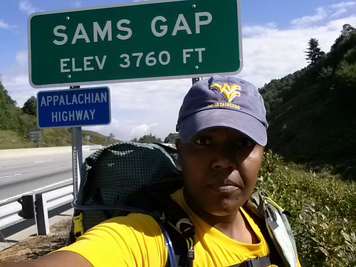
Mandatory selfie

A good place to enjoy lunch
Departing Sams Gap the trail goes through a gate, switchbacks up a hillside offering the last views of the highway and the western slope of the ridge. Just as I was happily tooling along, unconcerned, the tiptoe monster hit. The incline shot straight up, for no apparent reason, as usual, but this seemed a little more difficult. Oh right, I topped off my water before I left the shelter this morning, so there’s an extra 3 pounds sloshing around in my pack. There were a couple of cars parked down at Sams Gap, and I figured folks were out for a day hike up to Big Bald. There is a road going up to the bald that cuts off a large chunk of mileage, but it’s a private road going through the Wolf Laurel Resort, and they don’t give us regular common folks access to it, so the alternative is parking where US 23 runs under I-26.

Little did I know what significance Sams Gap and this picture would hold in the near future. Ignorance is truly bliss.
Right before Street Gap (mi 319.7, elev 4100′), the woods opened up to an overgrown meadow that offered up a nice view of the resort up on the ridgeline, but immediately an uneasy feeling swept over me when I glanced at my notes. I can see the resort from here to my right. The resort is on the ridgeline with Big Bald. Big Bald is to my left. I’m looking up at where I have to hike to get to the top. That’s Big Bald looming up ahead, and I’m far away. Big Bald is far away. That’s where I have to hike.
For the first time I can recall, I’m looking UP at where I need to go to summit. It’s not the same as looking up to Roan or the balds from Carver’s Gap or looking toward Hump Mountain from Bradley Gap. They gradually went up. This time I was not only looking UP, but it loomed far off, and there were a few hills and gaps to be traversed before I got there. No ****ing way am I going up there. Yes you are, so stop bitching about it and get to walking. You’ve hiked up Roan Mountain in the pouring rain, you summited Mount Rogers, the highest peak in Virginia, and you’re going to climb up to Big Bald. Today.

This is the view of Big Bald from the meadow. Yeah, I’m screwed.
Thinking back to my trip up to Roan when I had no water, I topped off, even though my app said there were several springs on the way up. Along the way two older ladies doing a day hike gave me the right-of-way coming uphill. “Hey you might as well keep walking because I’m taking a break right here” I called out. They laughed and came down to talk to me. One of them noticed my West Virginia University hat and said she was from near Parkersburg. “You have about an hour and a half to go, and when you get up there, you’ll be amazed”. Well I certainly hope so. “Just take breaks and you’ll be fine”. Well, I’ll have to try that, because usually a “break” to me is not walking for 90 seconds and taking pictures (with my pack still on), but coming up from Sams Gap, there were times where some of the logs, rocks, and blowdowns that looked like natural chairs were taken advantage of.
During the course of the day, my gait went from a confident stride to a steady walk to an ambivalent wobbling along. My steps weren’t steady, my torso was pitching to and fro like a drunkard, and I was generally feeling out of it. Every step was labored and I was no longer light on my feet. I’d hit the wall. More like the wall hit me. Several times I stopped, tossed my pack to the side, and sat down to catch my breath and get my bearings. A poster on Whiteblaze once opined “The one bad thing about being a section hiker is that you never get your trail legs”. How true. Every time you go out, just when you start to get your mojo, it’s time to go back to the daily frind of work and home.
The data book says there was a blue-blazed bad weather side trail and then a spring .4 miles from the summit. I passed the side trail, saw a building or some kind of structure, passed another overgrown trail that led to something that looked like part of a ski lift (?) or a powerline. Just when I thought the top was getting closer, the trail turned and there was Big Bald, STILL looming up ahead on the next ridgeline. A dejected sigh escaped from somewhere deep inside me. I double checked the map, and yep, it’s ahead of me, not to my right.
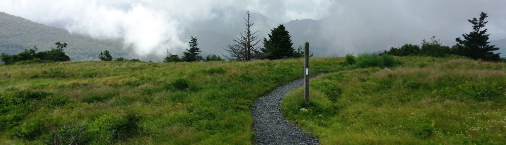
Why the hell am I doing this? Yeah, this view better blow me away. Okay, wait, here’s a spring, and this should be the one that’s a half mile fromn the top. Nope. I passed that, and then another, and then another, and then another. Whatever. I’m just going to keep walking until the sun goes down, and then sit down until the sun comes up again, and maybe sometime next year I’ll get to where I’m going. Finally the trail curved around and the trees opened up to the exposed summit.

Why are the clouds rolling in?
Seriously? I freaking went through all this just to get to the top and there’s NOTHING TO SEE? All of Big Bald was being swallowed up by clouds, clouds from a sky that partly cloudy but mostly sunny on the way up, but seemingly congregated up here just for me, just in time for my arrival, this big gray mass of bullshit whose sole purpose is to keep me from enjoying the fruits of my labor. I almost chukked my trekking poles across the field. Please God, just give me some reward. Anything.
It felt like something broke loose inside me and a lump formed in my throat. I was going through an incredibly difficult situation at work; the trail was my only respite, and now the trail was against me. A lone tear formed on the corner of my eye. Weeks and months of frustration and stress and difficulty was finally coming to a head. Screw it. Shake it off. My disappointment turned into mild annoyance as I set up camp in the mist and attempted to get a fire going.
There was a guy with a camera and binoculars on the far side of the bald; the ladies earlier today said there was a birding operation going on up here, and that they were asked politely to “keep moving”. Well, I’m not moving, for anyone that’s for sure. At this point I’ll cause a scene if I have to…so anyway, a couple with two dogs came by (cute dogs by the way, one was a handsome American Bulldog just like mine). They were the distraction I needed to calm down and get my mind off of the bad mood I was in. We conversed for a while, and another lady with the birding operation came by and talked to us before she went back to her work. The clouds (thankfully) started breaking, but not enough to offer a clear 360 degree view. It is what it is and I’ll have to take what I can get.

Puppies! Gracie (l) and Charlie (r)
There was room to set a tent up pretty much anywhere on top of Big Bald, so I moved my tent across the gravel “road” to the far eastern side of the summit, thinking what the heck, I’ll wake up to an awesome sunrise and this will make it all better. There was no rain forecast for the next day, but the clouds would roll in, then clear, then roll in again. Lather, rinse, repeat. The rest of the evening was spent taking pictures of the sunset and panoramic photos and trying to stretch my aching and fatigued legs out.

At this point, I knew I wouldn’t make it to Erwin tomorrow (which was visible off in the distance), so the plan was changed to make a stop at No Business Knob Shelter tomorrow, then trek the last few miles downhill to Uncle Johnny’s. That’s doable. The thermometer read 50 degrees, the humidity was up, and condensation started forming in the tent, which means my sleeping bag, which is a moisture magnet, started taking on the familiar smell of “damp”. Ick. Total time on trail today was 7:06, 3309 calories burned. the kicker- average pace was 1.3 mph. That’s abysmal. That sucks ass.
Hello Tramadol. Work your magic, because I’m done.
