22 OCT 14
Mount Mitchell State Park
Miles today: ~5
“Any goal worth achieving involves an element of risk.”
-Dean Karnazes
Driving up to Mt Mitchell State Park is a battle against gravity and switchbacks. NC Route 80 took me up to the Blue Ridge Parkway, which would take me directly to the park. NC 80 is probably one of the most winding, twisting, curving sections of road I’ve been on in years. The speed limit was 35 (I think) but I never got over 25 once it started climbing. That has to be hell on engines and transmissions. After what happened last month coming back from a hike in Erwin, TN, I pay close attention to things like that.
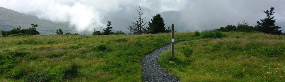
Once I got past the park entrance the road was protected from the winds that were obviously blowing at the top. It was all the southern Appalachian spruce-fir forest where the venerable Frasier Fir, Red Spruce, and a few hardwoods are the only trees to be found. Not far from the Headquarters, however, the road traversed an exposed ridge, and immediately all the trees were covered in rime which completely transformed the scenery from an autumn palette of orange and yellow hues to one of an alpine winter forest.
Rime is formed when super cooled water droplets from the clouds and fog enveloping high summits freezes immediately when it touches an object. On the way up the skies were 90% clear, but at the park HQ there was a cloud/fog rushing by. Clouds look so calm and serene when viewed from the ground, but when you’re actually at the same altitude, they seem to take on a sinister tone, screaming by somewhat ferociously.
I checked in at the lobby, and after briefing my plans, the ranger said I would have my pick of the nine campsites for the night (probably since no one was crazy enough to camp out in 20 degree weather) (first omen), all I had to do was set up a tent to “claim” it and a ranger would come by around 7 to collect the $15 fee and $5 for a cord of wood if I took one. The drive to the campsite was short, passing by the park restaurant on the way up. At the lot, there was a sign that said “Elevation here 6330 feet”. So it is!

I walked around to all 9 campsites, looking for the best one that didn’t have the tent pad exposed, and ultimately chose #2. None of the sites were on the lee side of the mountain, so everything was going to get some wind, but at least the tent pad at site 2 butted right up against a stand of trees that somewhat acted as a wind break. The water point (non-potable) bathrooms (heated!), and parking lot were all within 100 feet. The sites have had-packed sand tent pads, a grill, picnic bench, and a metal, lockable bear box for your food.
I started setting up camp, but inevitably made several trips back to my truck, forgetting something or the other. My brain and lungs quickly reminded me that they were not accustomed to the reduced oxygen at this elevation; I got dizzy and started seeing starts as I was blowing up my sleeping pad! Once I was done, I had a quick lunch consisting of an apple and MRE Potatoes Au Gratin. Yeah, it sounds gross, but I don’t care what you think, that stuff is good.
Let’s get to the reason I came up here- hiking! I put about 15 pounds of gear in my backpack, to include my cold weather sleeping bag and Gore-Tex bivvy cover- didn’t want to risk having $400 worth of gear stolen. I took the red-blazed Campground Spur Trail to the summit area. There is a parking lot & gift shop where you can pretty much drive to just shy of the top, and walk up 300 meters to the actual summit, so imagine my surprise when I popped out of the woods into a small crowd of people. Of course, I was the only person wearing a backpack. Hell, I was the only person who wasn’t covered in goose down and several layers of wool.
Even with the temps around 36 degrees, the hike warmed me up enough to just wear a baselayer /mid-weight top combo, lightweight gloves & fleece cap. That all changed once I stopped moving to take the required 300 photos- that breeze started sucking the heat right out of me. 
I’d brought my tripod up with me so I got a couple great selfies with it. At the summit there was a pair of women taking in the northwest view (there are panoramic pictures mounted along the rails showing you what peaks and ranges you’re looking at). Looking out towards Big Bald, I said “yeah, I was at the top of that last month”. One of the ladies turned and said “Really?” I went on to explain to them how the Appalachian Trail runs along some of the peaks in the photos. They were impressed, especially when I told them I was camping on the mountain tonight. “That’s awesome, and we’ll be thinking about you when we’re in our cozy hotel room” the other said.

So, I left the summit (getting way too cold up there just standing around) and hit the Old Mitchell Trail. The Old Mitchell Trail is the one that actually qualifies for the “South Beyond 6,000”.
Fun Fact: “The South Beyond 6000 (SB6K) is an organized program for encouraging hikers to climb the forty 6000 foot peaks in the Southern Appalachian Mountains. The privilege of belonging is earned and can only be shared among those who have pushed onward and upward on foot to the tops of these peaks.”- from the Carolina Mountain Club website
Well I wasn’t earning that today, but at least I was hiking something. Anyway, I took the Old Mitchell Trail to the Camp Alice Trail then headed down the Commissary Trail a little ways. The Camp Alice Trail was extremely rocky. Extremely. Meaning all of it. It was a bitch at times, but if you’ve read any of my other posts you’ll know I’m not a fan of rock-hopping to begin with.
I timed my pace on that section to see how much of a difference there was going downhill versus going uphill. The time down was 35 minutes (going very slowly again, rocks) and back up took me 45 minutes. Not too shabby. Since the trails were mainly in the deep woods, I stayed relatively warm, but whenever the path peeked out on a ridgeline or open area, that hawk was waiting.


I stopped at the Gift Shop to buy a few souvenirs, to include some Balsam sachets that smelled pretty good, and a souvenir compass/thermometer keychain. I also made a cursory pass through the museum. It was getting close to dinner time so I set back off for the Campground Spur Trail.
Once back to camp, I set up my Army issue modular sleeping system (40 degree bag, 0 degree bag, and Goretex bivvy cover) & got the rest of my gear situated for the evening. The ranger mentioned decent food at the restaurant, decided to go to there for a nice big dinner. Since I hadn’t seen anyone come by to collect the camping fee, I stopped by the ranger station to pay for my campsite & firewood but no one was there. I guess they locked up and left early for the day (second omen).
Between the end of my hike & now the winds had whipped up and the cloud cover was no longer intermittent; the entire area was enveloped in a giant, continuous cloud scudding by. According to my newly purchased thermometer, the ambient air temp at site was 31 degrees. The winds were at least 20-25 mph and gusting higher. I walked back down to my truck to retrieve a few more necessary items.
Sitting inside I contemplated the fact that 1- no one else is up here at the campsites, 2- the extremely cold conditions, 3- my not being acclimated to very cold weather just yet, and 4- the park shuts down at 7 or 8. Should i stay or should I go? Sometimes you get a peculiar feeling in your gut that tells you a decision point has been reached and it time to poop or get off the pot, so to speak. This was one of those times. I decided that possibly ending up as a frozen chocolate popsicle wasn’t how I wanted to end my weekend, so the decision was made to bail out. Again.
So, I broke down my tent and gear & got on road around 6 pm. I had two choices- either go to Erwin, stay the night there & hike the section I hadn’t finished tomorrow, stay in Asheville for the night then head back, or go BACK to Charlotte tonight and head home the next day. Hell. Left a note on the now-locked Ranger Station door with my name saying I wasn’t staying overnight and that site #2 was officially cleared, and paid for my firewood (throwing in an extra $5 as a donation).
I enjoyed the sunset ride down the Blue Ridge Parkway into Asheville but not the actual driving- I soon grew weary of hearing my truck engine revving crazily up and down the hills (averaged 9 MPG since route 80). Passed by a few nice log cabin-esque homes in the northern Asheville outskirts. Stopped at a McDonald’s for a McRib, fries, and coke (just because) then jumped on Interstate 240 headed back to Charlotte, happy to not have frozen to death on Mount Mitchell!
